ISSA Explanatory Supplement
I. Introduction
B. The IRAS Survey
Complete details of the designs of the IRAS telescope and instruments, the IRAS sky survey and the IRAS data processing system, along with extensive descriptions of the IRAS data products, are contained in the IRAS Explanatory Supplement 1988, hereafter referred to as the Main Supplement. Short descriptions of the IRAS survey instrument and the survey design are included here for easy reference.
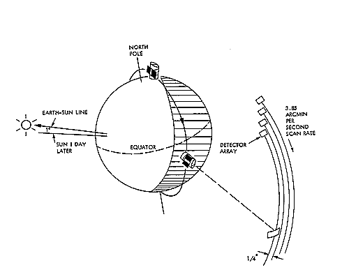
IRAS was launched into a Sun-synchronous polar orbit at 900 km altitude over the Earth's terminator to facilitate long scans of the sky along portions of circles centered on the Sun (Figure I.B.1 and Main Supplement, §III.B). This orbit geometry would have allowed the IRAS telescope to view the whole sky in exactly six months if it had remained pointed exactly 90° from the Sun. The IRAS survey strategy used the ability of the satellite to point at varying angles from the Sun to complete two confirming surveys of 98% of the sky and a third confirming survey of 75% of the sky within the ten month operating period of the satellite.
 |
|---|
|
Figure I.B.1 A schematic drawing of the orbital geometry.
The orbital altitude, 900 km, and inclination, 99°, combined
with the Earth's equatorial bulge, led to a precession of the plane of
the orbit of about 1° per day. As a result, the orbit plane
constantly faced the Sun as the satellite orbited near the Earth's
terminator. By pointing the satellite radially away from the Earth, the
cold telescope was shielded from the heat loads from the Sun and Earth
while providing natural scanning motion across the entire sky in about
six months. A sequence of hours-confirming scans on the celestial
sphere is also shown.
larger largest |
A significant feature of the IRAS survey strategy is that zodiacal emission, arising from interplanetary dust in the solar system, presented a constantly changing source of foreground emission through which IRAS observed. Two observations of the same point on the celestial sphere separated by as little as a few days would measure significantly different surface brightnesses because the Earth moved in its orbit and changed the line of sight through the zodiacal dust cloud. This variation produced steep gradients in individual HCON images where adjacent locations on the sky were scanned at different times. This prevented direct co-addition of separate HCONs. The variation in zodiacal foreground was most troublesome at 12 and 25 µm (15% to 30% depending on the HCON) which fall near the peak wavelength of the zodiacal emission. At the longer wavelengths, diffuse Galactic emission becomes much stronger than zodiacal emission, reducing the effects of zodiacal variation.
 |
|---|
|
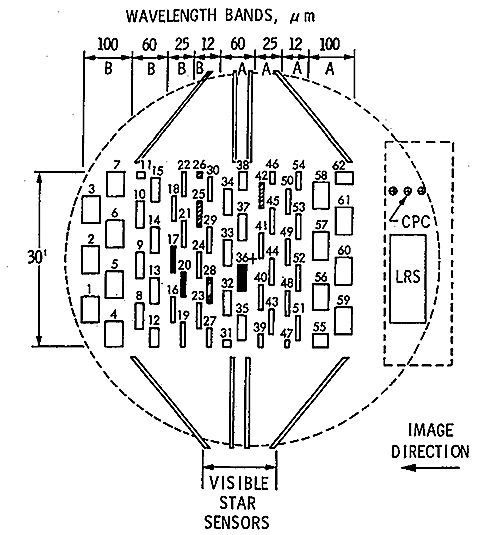
Figure I.B.2. A schematic drawing of the IRAS focal plane.
The numbered rectangles in the central portion each represent the
field of view of a detector, filter and field lens combination. The image
of a source crossed the focal plane in the Y direction as indicated.
The filled-in detectors were inoperative, while the cross-hatched
detectors showed degraded performance during the mission.
larger largest |
The focal plane array of the IRAS survey instrument
consisted of 62 detectors with either 15 or 16 detectors at each
of the four IRAS wavelengths (Figure I.B.2). The telescope was
oriented so that, during survey scans, the image of the sky moved
across the array in the long direction at 3.85' s-1,
producing complete coverage of a 0.5°-wide swath of sky. The four
staggered rows of detectors in each wavelength band were designed
to provide slightly more than 100% overlap of the detectors
during a single scan. This provides slightly more than two samples
per detector in the cross-scan direction, which substantially
undersamples the telescope point spread function at the
shorter wavelengths. Sampling rates of 16, 16, 8 and
4 samples per second of the 12, 25, 60 and 100 µm detectors,
respectively,
combined with the 3.85' s-1 scan rate and the
detector widths of 0.75', 0.75', 1.5'
and 3.0', gives about a 50% oversampling in the in-scan
direction. All 62 detectors did not operate correctly
in orbit. Two nearly adjacent dead 25 µm detectors and one
dead 60 µm detector left holes in the focal plane swath. Four
noisy or partially blind detectors affected the 12 and 25 µm
arrays (Figure I.B.2).